نشانی: 49 (From 49 To 99) LABEL ST, MONTCLAIR, NJ 07042-40ND, USA
؟07042-40ND چیست 07042-40ND یک کد فشرده 5 به همراه 4 عدد از 49 (From 49 To 99) LABEL ST, MONTCLAIR, NJ, USA است. اطلاعات بیشتر در زیر آمده است.
07042-40ND اطلاعات اولیه

پیشمسیر خیابان?
A geographic direction that precedes the street name.
| خیابان?
The official name of a street as assigned by a local governing authority. The Street Name column contains only the street name and does not include directionals (EAST, WEST, etc.) or suffixes (ST, DR, BLVD, etc.). This element may also contain literals, such as PO BOX, GENERAL DELIVERY, USS, PSC, or UNIT. Numeric street names that have numeric components that are four characters (or less) in length at are justified such that the low-order digit of the number is positioned in the fourth position of the street name column. This shift is made so that the numeric street names appear in numeric sequence.
| پسوند خیابان?
The street suffix:
For Example:
ST = Street
RD = Road
DR = Drive
LN = Lane
| شهر | نوع ثبت?
An alphabetic value that identifies the type of data in the record. Record type codes include the following:
G = General delivery
H = Highrise
F = Firm
S = Street
P = PO box
R = Rural route/highway contract
| وضعیت |
|---|---|---|---|---|---|
| CHESTNUT | ST | MONTCLAIR | S | معتبر | |
| CHRISTOPHER | ST | MONTCLAIR | S | معتبر | |
| WALNUT | ST | MONTCLAIR | S | معتبر | |
| OXFORD | ST | MONTCLAIR | S | معتبر | |
| LABEL | ST | MONTCLAIR | S | معتبر |
نشانی

07042-40ND مربوط به آدرس های زیر است.
| لیست آدرس | وضعیت |
|---|---|
| 1 (From 1 To 19) CHESTNUT ST, MONTCLAIR, NJ 07042-40ND, USA | معتبر |
| 20 (From 20 To 40) CHESTNUT ST, MONTCLAIR, NJ 07042-40ND, USA | معتبر |
| 11 (From 11 To 41) CHRISTOPHER ST, MONTCLAIR, NJ 07042-40ND, USA | معتبر |
| 84 (From 84 To 88) WALNUT ST, MONTCLAIR, NJ 07042-40ND, USA | معتبر |
| 100 (From 100 To 198) OXFORD ST, MONTCLAIR, NJ 07042-40ND, USA | معتبر |
| 101 (From 101 To 199) OXFORD ST, MONTCLAIR, NJ 07042-40ND, USA | معتبر |
| 2 (From 2 To 18) CHESTNUT ST, MONTCLAIR, NJ 07042-40ND, USA | معتبر |
| 21 (From 21 To 39) CHESTNUT ST, MONTCLAIR, NJ 07042-40ND, USA | معتبر |
| 49 (From 49 To 99) LABEL ST, MONTCLAIR, NJ 07042-40ND, USA | معتبر |
لطفاً برای مشاهده کل لیست ، بر روی "نمونه های آدرس بیشتر" کلیک کنید.
نشانی مثال
MONTCLAIR NJ 07042-40ND
UNITED STATES OF AMERICA
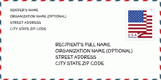
07042-40ND نمونه پاکت

-
این نمونه ای از پاکت نامه ایالات متحده است. اطلاعات فرستنده را در بالا سمت چپ و اطلاعات گیرنده را در پایین سمت راست وارد کنید. اطلاعات لازم نام کامل فرستنده/گیرنده ، آدرس خیابان ، شهر ، ایالت و کد پستی است. اطلاعات آدرس گیرنده برای مرجع شما داده شده است. به طور کلی ، اگر از کد پستی کامل 9 رقمی مطمئن نیستید ، فقط می توانید کد پستی 5 رقمی را پر کنید تا از دست دادن بسته جلوگیری شود.
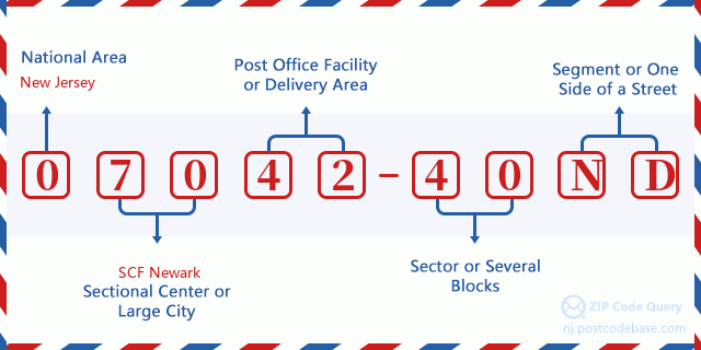
07042-40ND معنای اساسی
-
هر رقم کد پستی 07042-40ND مخفف چیست؟ کد ZIP+4 از دو بخش تشکیل شده است، پنج رقم اول را می توان در اداره پست قرار داد، و چهار رقم آخر می تواند یک بخش جغرافیایی را در منطقه تحویل پنج رقمی مشخص کند. 6-7 رقم بخش یا چند بلوک را مشخص می کند و رقم 8-9 نشان دهنده بخش یا یک طرف خیابان است.

نقشه آنلاین

این نقشه آنلاین آدرس 49 LABEL ST, MONTCLAIR است. برای حرکت و زوم میتوانید از دکمه استفاده کنید. اطلاعات نقشه تنها برای مرجع است.
نشانی: 49 (From 49 To 99) LABEL ST, MONTCLAIR, NJ 07042-40ND, USA
دیدگاه


افزودن دیدگاه جدید