Jesteś tutaj

Adres: 371 (From 371 To 399) FREEWAY DR E (East), EAST ORANGE, NJ 07018-26ND, USA

Co to jest 07018-26ND? 07018-26ND to kod pocztowy 5 Plus 4 liczba 371 (From 371 To 399) FREEWAY DR E (East), EAST ORANGE, NJ, USA. Bliższe informacje poniżej.

07018-26ND Podstawowe informacje

img_Postal
  • Kod Pocztowy 5 Plus 4:

    07018-26ND
  • Kod Pocztowy 5:

    07018
  • Plus 4?
    4-digits that are used to identify a geographic segment within the 5-digit delivery area, such as a city block or a group of apartments or an individual high-volume receiver of mail, or any other unit that could use an extra identifier to aid in efficient mail sorting and delivery. This code is the low end of the range of +4 Codes that pertain to this ZIP Code. ZIP+4 Codes associated with nondelivery areas are composed of valid ZIP sector numbers and "ND" for the ZIP segment number, for example 12345-12ND. Non-deliverable areas are areas to which the USPS does not deliver mail, such as vacant lots and land that borders railroad tracks. Mailers should not match an address identified as a nondelivery area. If you absolutely must have numeric characters in the Plus4Code column, you may treat "ND" values as "00" (zero zero).
    :
    26ND
  • Kraj:

    U.S. - Stany Zjednoczone
  • Państwo/stan:

    NJ - New Jersey
  • Hrabstwo:

    CountyFIPS: 34013 - Essex County
  • Miasto:

    EAST ORANGE
  • Ulica?
    The official name of a street as assigned by a local governing authority. The Street Name column contains only the street name and does not include directionals (EAST, WEST, etc.) or suffixes (ST, DR, BLVD, etc.). This element may also contain literals, such as PO BOX, GENERAL DELIVERY, USS, PSC, or UNIT. Numeric street names that have numeric components that are four characters (or less) in length at are justified such that the low-order digit of the number is positioned in the fourth position of the street name column. This shift is made so that the numeric street names appear in numeric sequence.
    :
    FREEWAY DR
  • Sufiks Ulicy?
    The street suffix: For Example: ST = Street RD = Road DR = Drive LN = Lane
    :
    DR (Droga Wiejska)
  • Pokierunkowy Ulicy?
    A geographic direction that precedes the street name. For Example: 472 MAIN ST N Street Pre-Direction Abbreviation = N Spaces = No pre-direction N = North NE = Northeast E = East SE = Southeast S = South SW = Southwest W = West NW = Northwest
    :
    E (East)
  • Rodzaj Danych?
    An alphabetic value that identifies the type of data in the record. Record type codes include the following: G = General delivery H = Highrise F = Firm S = Street P = PO box R = Rural route/highway contract
    :
    S: Ulica

Adres

img_region

07018-26ND odpowiada następującym adresom.

Lista adresówStatus
370 (From 370 To 424) FREEWAY DR E (East), EAST ORANGE, NJ 07018-26ND, USAważny
401 (From 401 To 425) FREEWAY DR E (East), EAST ORANGE, NJ 07018-26ND, USAważny
401 (From 401 To 425) FREEWAY DR E (East), EAST ORANGE, NJ 07018-26ND, USAnieważny
371 (From 371 To 399) FREEWAY DR E (East), EAST ORANGE, NJ 07018-26ND, USAważny

Adres odpowiadający kodowi ZIP+4 07018-26ND uległ zmianie. Przechowujemy nowe i stare informacje o kodzie pocztowym 07018-26ND, sprawdź status. Jeśli Twój adres jest oznaczony na tej stronie jako nieprawidłowy, nie będziesz mógł użyć 07018-26ND jako pocztowego kodu pocztowego.

Kliknij "Więcej przykładów adresów", aby wyświetlić całą listę.

[+]Więcej przykładów adresów

Adres Przykład

img_region
Adres składa się z następujących wierszy:
371 FREEWAY DR E (East)
EAST ORANGE NJ 07018-26ND
UNITED STATES OF AMERICA
lub Możesz sprawdzić przykład koperty poniżej, aby uzyskać więcej informacji.

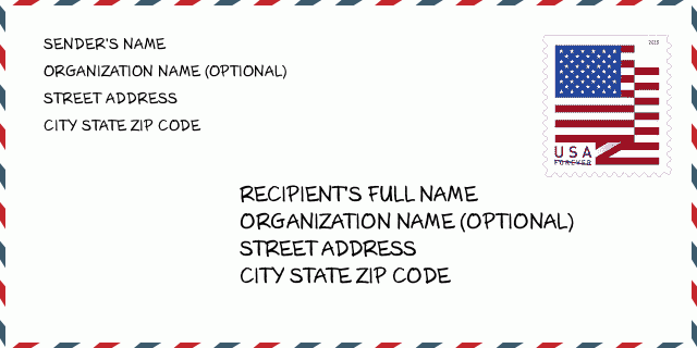
07018-26ND Przykład Koperty

img_envelope
  • To jest przykład koperty amerykańskiej. Wpisz informacje o nadawcy w lewym górnym rogu i informacje o odbiorcy w prawym dolnym rogu. Niezbędne informacje to imię i nazwisko nadawcy/odbiorcy, adres, miasto, województwo i kod pocztowy. Dane adresowe odbiorcy zostały podane w celach informacyjnych. Ogólnie rzecz biorąc, jeśli nie masz pewności co do pełnego 9-cyfrowego kodu pocztowego, możesz wpisać tylko 5-cyfrowy kod pocztowy, aby uniknąć utraty paczki.

    ZIP Code: 07018-26ND

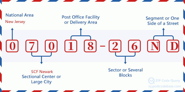
07018-26ND Podstawowe znaczenie

img_envelope
  • Co oznacza każda cyfra kodu pocztowego 07018-26ND? Kod pocztowy + 4 składa się z dwóch części, pierwsze pięć cyfr może znajdować się w urzędzie pocztowym, a ostatnie cztery cyfry mogą identyfikować segment geograficzny w pięciocyfrowym obszarze dostawy. Cyfry 6-7 oznaczają sektor lub kilka bloków, a cyfry 8-9 oznaczają odcinek lub jedną stronę ulicy.

    ZIP Code: 07018-26ND

Mapa

Mapa

To mapa sieciowa adresu 371 FREEWAY DR, EAST ORANGE. Mapę można przybliżyć. Mapa przeznaczona jest wyłącznie dla celów informacyjnych.

Adres: 371 (From 371 To 399) FREEWAY DR E (East), EAST ORANGE, NJ 07018-26ND, USA

Komentarz

Komentarz

Dodaj komentarz