Sie sind hier

Adresse: 221 W (West) GRAND AVE STE 105 (From 105 To 204), MONTVALE, NJ 07645-1729, USA

Was ist 07645-1729? 07645-1729 ist ein PLZ-Code 5 Plus 4 Zahl von 221 W (West) GRAND AVE STE 105 (From 105 To 204), MONTVALE, NJ, USA. Nachfolgend finden Sie Detailinformationen.

07645-1729 Grundinformation

img_Postal
  • Postleitzahl 5 Plus 4:

    07645-1729
  • Postleitzahl 5:

    07645
  • Plus 4?
    4-digits that are used to identify a geographic segment within the 5-digit delivery area, such as a city block or a group of apartments or an individual high-volume receiver of mail, or any other unit that could use an extra identifier to aid in efficient mail sorting and delivery. This code is the low end of the range of +4 Codes that pertain to this ZIP Code. ZIP+4 Codes associated with nondelivery areas are composed of valid ZIP sector numbers and "ND" for the ZIP segment number, for example 12345-12ND. Non-deliverable areas are areas to which the USPS does not deliver mail, such as vacant lots and land that borders railroad tracks. Mailers should not match an address identified as a nondelivery area. If you absolutely must have numeric characters in the Plus4Code column, you may treat "ND" values as "00" (zero zero).
    :
    1729
  • Land:

    U.S. - Vereinigte Staaten
  • Bundesland:

    NJ - New Jersey
  • Grafschaft:

    CountyFIPS: 34003 - Bergen County
  • Stadt:

    MONTVALE
  • Frontrichtung der Straße :

    W (West)
  • Straße?
    The official name of a street as assigned by a local governing authority. The Street Name column contains only the street name and does not include directionals (EAST, WEST, etc.) or suffixes (ST, DR, BLVD, etc.). This element may also contain literals, such as PO BOX, GENERAL DELIVERY, USS, PSC, or UNIT. Numeric street names that have numeric components that are four characters (or less) in length at are justified such that the low-order digit of the number is positioned in the fourth position of the street name column. This shift is made so that the numeric street names appear in numeric sequence.
    :
    GRAND AVE
  • Nachtrags-Begleitzeichen der Straße?
    The street suffix: For Example: ST = Street RD = Road DR = Drive LN = Lane
    :
    AVE (Allee)
  • Rekordtyp?
    An alphabetic value that identifies the type of data in the record. Record type codes include the following: G = General delivery H = Highrise F = Firm S = Street P = PO box R = Rural route/highway contract
    :
    H: Hochhaus

Adresse

img_region

07645-1729 entspricht den folgenden Adressen.

AdresslisteStatus
221 W (West) GRAND AVE, MONTVALE, NJ 07645-1729, USAgültig
221 W (West) GRAND AVE STE 100 (From 100 To 101), MONTVALE, NJ 07645-1729, USAgültig
221 W (West) GRAND AVE STE 105 (From 105 To 203), MONTVALE, NJ 07645-1729, USAgültig
221 W (West) GRAND AVE STE 102A (From 102A To 102C), MONTVALE, NJ 07645-1729, USAgültig
221 W (West) GRAND AVE STE 105 (From 105 To 204), MONTVALE, NJ 07645-1729, USAgültig

Adresse Beispiel

img_region
Die Adresse besteht aus folgenden Zeilen:
221 W (West) GRAND AVE
MONTVALE NJ 07645-1729
UNITED STATES OF AMERICA
oder Weitere Informationen finden Sie im folgenden Umschlagbeispiel.

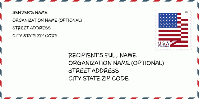
07645-1729 Umschlagbeispiel

img_envelope
  • Dies ist ein Beispiel für einen US-Umschlag. Geben Sie oben links die Informationen des Absenders und unten rechts die Informationen des Empfängers ein. Die erforderlichen Informationen sind der vollständige Name des Absenders/Empfängers, die Anschrift, der Ort, das Bundesland und die Postleitzahl. Die Adressdaten des Empfängers wurden zu Ihrer Information angegeben. Im Allgemeinen gilt: Wenn Sie sich bei der vollständigen 9-stelligen Postleitzahl nicht sicher sind, können Sie nur die 5-stellige Postleitzahl eingeben, um einen Paketverlust zu vermeiden.

    ZIP Code: 07645-1729

07645-1729 Grundlegende Bedeutung

img_envelope
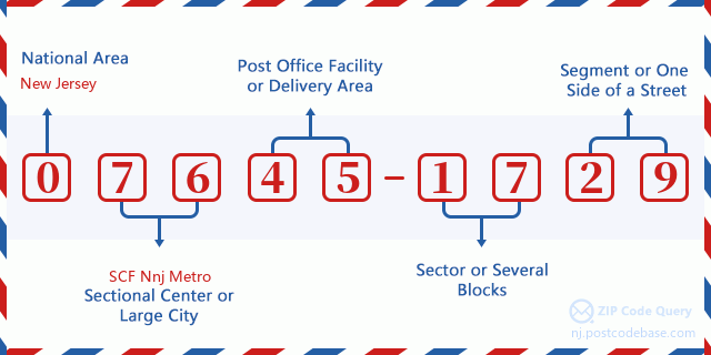
  • Wofür steht jede Ziffer der Postleitzahl 07645-1729? Die Postleitzahl+4 besteht aus zwei Teilen, wobei die ersten fünf Ziffern die Poststelle angeben und die letzten vier Ziffern ein geografisches Segment innerhalb des fünfstelligen Zustellgebiets identifizieren können. Die Ziffern 6-7 bezeichnen einen Sektor oder mehrere Blöcke und die Ziffern 8-9 bezeichnen ein Segment oder eine Straßenseite.

    ZIP Code: 07645-1729

Online Map

Online Map

Das ist Online-Karte der adresse 221 W (West) GRAND AVE, MONTVALE. Sie können Knopf verwenden, um zu bewegen und vergrößern/ verkleinern. Die Karteninformation dient nur als Referenz.

Adresse: 221 W (West) GRAND AVE STE 105 (From 105 To 204), MONTVALE, NJ 07645-1729, USA

Kommentar

Kommentar

Neuen Kommentar schreiben