ที่อยู่: 381 BROAD ST APT A2001, NEWARK, NJ 07104-5307, USA
07104-5307คืออะไร 07104-5307 เป็นรหัสไปรษณีย์ห้าบวกสี่หลัก 381 BROAD ST APT A2001, NEWARK, NJ, USA มีรายละเอียดดังต่อไปนี้
07104-5307 ข้อมูลพื้นฐาน

ทิศทางตรงหน้าถนน ?
A geographic direction that precedes the street name.
| ถนน?
The official name of a street as assigned by a local governing authority. The Street Name column contains only the street name and does not include directionals (EAST, WEST, etc.) or suffixes (ST, DR, BLVD, etc.). This element may also contain literals, such as PO BOX, GENERAL DELIVERY, USS, PSC, or UNIT. Numeric street names that have numeric components that are four characters (or less) in length at are justified such that the low-order digit of the number is positioned in the fourth position of the street name column. This shift is made so that the numeric street names appear in numeric sequence.
| คำต่อท้ายถนน ?
The street suffix:
For Example:
ST = Street
RD = Road
DR = Drive
LN = Lane
| เมือง | ประเภทระเบียน?
An alphabetic value that identifies the type of data in the record. Record type codes include the following:
G = General delivery
H = Highrise
F = Firm
S = Street
P = PO box
R = Rural route/highway contract
| สถานะ |
|---|---|---|---|---|---|
| MANCHESTER | PL | NEWARK | H | ถูกต้อง | |
| BROAD | ST | NEWARK | H | ถูกต้อง |
ที่อยู่

07104-5307 ตรงกับที่อยู่ต่อไปนี้
| รายการที่อยู่ | สถานะ |
|---|---|
| 38 MANCHESTER PL, NEWARK, NJ 07104-5307, USA | ถูกต้อง |
| 381 BROAD ST APT A2001, NEWARK, NJ 07104-5307, USA | ถูกต้อง |
ที่อยู่ ตัวอย่าง
NEWARK NJ 07104-5307
UNITED STATES OF AMERICA
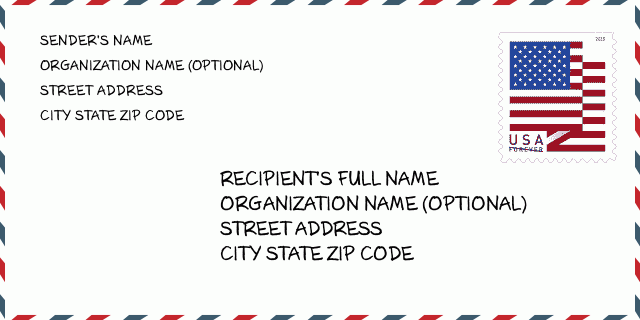
07104-5307 ตัวอย่างซองจดหมาย

-
นี่คือตัวอย่างซองจดหมายของสหรัฐฯ กรอกข้อมูลผู้ส่งที่ด้านบนซ้ายและข้อมูลผู้รับที่ด้านล่างขวา ข้อมูลที่จำเป็นคือชื่อเต็มของผู้ส่ง/ผู้รับ ที่อยู่ เมือง รัฐ และรหัสไปรษณีย์ ข้อมูลที่อยู่ผู้รับได้รับสำหรับการอ้างอิงของคุณ โดยทั่วไป หากคุณไม่แน่ใจเกี่ยวกับรหัสไปรษณีย์ 9 หลักแบบเต็ม คุณสามารถกรอกรหัสไปรษณีย์ 5 หลักเท่านั้นเพื่อหลีกเลี่ยงการสูญหายของพัสดุ
07104-5307 ความหมายพื้นฐาน
-
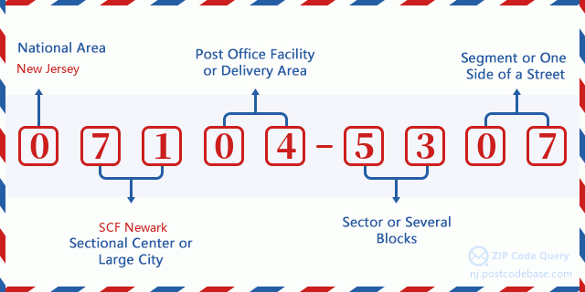
รหัสไปรษณีย์ 07104-5307 แต่ละหลักย่อมาจากอะไร ? รหัสไปรษณีย์ประกอบด้วยสองส่วน โดยสามารถระบุหมายเลขห้าหลักแรกไปยังที่ทำการไปรษณีย์ได้ และตัวเลขสี่หลักสุดท้ายสามารถระบุส่วนทางภูมิศาสตร์ภายในพื้นที่จัดส่งห้าหลักได้ ตัวเลข 6-7 หลักกำหนดส่วนหรือหลายช่วงตึก และตัวเลข 8-9 หลักกำหนดส่วนหรือด้านใดด้านหนึ่งของถนน

แผนที่ออนไลน์

นี่คือแผนที่อิเล็กทรอนิกส์ออนไลน์ที่ที่อยู่ 381 BROAD ST, NEWARKจับคู่นั้น คุณสามารถจะใช้ปุ่มบนแผนที่เพื่อเลื่อนและซูม ข้อมูลแผนที่นี้ เฉพาะสำหรับการอ้างอิงเท่านั้น
ที่อยู่: 381 BROAD ST APT A2001, NEWARK, NJ 07104-5307, USA
ความเห็น


แสดงความเห็น