Adres: 2000 (From 2000 To 2099) MILL POND CT, WALL TOWNSHIP, NJ 07719-3660, USA
Co to jest 07719-3660? 07719-3660 to kod pocztowy 5 Plus 4 liczba 2000 (From 2000 To 2099) MILL POND CT, WALL TOWNSHIP, NJ, USA. Bliższe informacje poniżej.
07719-3660 Podstawowe informacje

-
Kod Pocztowy 5 Plus 4:
07719-3660 -
Kod Pocztowy 5:
07719 -
Plus 4?36604-digits that are used to identify a geographic segment within the 5-digit delivery area, such as a city block or a group of apartments or an individual high-volume receiver of mail, or any other unit that could use an extra identifier to aid in efficient mail sorting and delivery. This code is the low end of the range of +4 Codes that pertain to this ZIP Code. ZIP+4 Codes associated with nondelivery areas are composed of valid ZIP sector numbers and "ND" for the ZIP segment number, for example 12345-12ND. Non-deliverable areas are areas to which the USPS does not deliver mail, such as vacant lots and land that borders railroad tracks. Mailers should not match an address identified as a nondelivery area. If you absolutely must have numeric characters in the Plus4Code column, you may treat "ND" values as "00" (zero zero).:
-
Kraj:
U.S. - Stany Zjednoczone -
Państwo/stan:
NJ - New Jersey -
Hrabstwo:
CountyFIPS: 34025 - Monmouth County -
Miasto:
WALL TOWNSHIP -
Ulica?MILL POND CTThe official name of a street as assigned by a local governing authority. The Street Name column contains only the street name and does not include directionals (EAST, WEST, etc.) or suffixes (ST, DR, BLVD, etc.). This element may also contain literals, such as PO BOX, GENERAL DELIVERY, USS, PSC, or UNIT. Numeric street names that have numeric components that are four characters (or less) in length at are justified such that the low-order digit of the number is positioned in the fourth position of the street name column. This shift is made so that the numeric street names appear in numeric sequence.:
-
Sufiks Ulicy?CTThe street suffix: For Example: ST = Street RD = Road DR = Drive LN = Lane:
-
Rodzaj Danych?S: UlicaAn alphabetic value that identifies the type of data in the record. Record type codes include the following: G = General delivery H = Highrise F = Firm S = Street P = PO box R = Rural route/highway contract:
Adres

- Prymarny Niski Numer Adresu?
A house, rural route, highway contract box, or post office box number; the numeric or alphanumeric component of an address preceding the street name; the low-end address in a range of addresses. Often referred to as house number.: 2000
- Prymarny Wysoki Numer Adresu?
A house, rural route, contract box, or Post Office box number. The numeric or alphanumeric component of an address preceding the street name. The high-end address in a range of addresses. Often referred to as house number.: 2099
- Nieparzysty/Parzysty Kod Prymarny Adresu?
Code that identifies the side or sides of a street for which a given address range is applicable. For street, highrise, firm and multi-carrier records, B = Both sides of a street, E = Even side of a street (even-numbered addresses in the range); O = Odd side of a street (odd-numbered addresses in the range). For general delivery, post office box, and rural route/highway contract records, this code will always be "B" (both).: Both of Odd and Even
- Podstawowy Zakres: 2000, 2001, 2002, 2003, 2004, 2005, 2006, 2007, 2008, 2009, 2010, 2011, 2012, 2013, 2014, 2015, 2016, 2017, 2018, 2019, 2020, 2021, 2022, 2023, 2024, 2025, 2026, 2027, 2028, 2029, 2030, 2031, 2032, 2033, 2034, 2035, 2036, 2037, 2038, 2039, 2040, 2041, 2042, 2043, 2044, 2045, 2046, 2047, 2048, 2049, 2050, 2051, 2052, 2053, 2054, 2055, 2056, 2057, 2058, 2059, 2060, 2061, 2062, 2063, 2064, 2065, 2066, 2067, 2068, 2069, 2070, 2071, 2072, 2073, 2074, 2075, 2076, 2077, 2078, 2079, 2080, 2081, 2082, 2083, 2084, 2085, 2086, 2087, 2088, 2089, 2090, 2091, 2092, 2093, 2094, 2095, 2096, 2097, 2098, 2099.
Kliknij "Więcej przykładów adresów", aby wyświetlić całą listę.
2000 MILL POND CT, WALL TOWNSHIP, NJ 07719-3660
2001 MILL POND CT, WALL TOWNSHIP, NJ 07719-3660
2002 MILL POND CT, WALL TOWNSHIP, NJ 07719-3660
2003 MILL POND CT, WALL TOWNSHIP, NJ 07719-3660
2004 MILL POND CT, WALL TOWNSHIP, NJ 07719-3660
2005 MILL POND CT, WALL TOWNSHIP, NJ 07719-3660
2006 MILL POND CT, WALL TOWNSHIP, NJ 07719-3660
2007 MILL POND CT, WALL TOWNSHIP, NJ 07719-3660
2008 MILL POND CT, WALL TOWNSHIP, NJ 07719-3660
2009 MILL POND CT, WALL TOWNSHIP, NJ 07719-3660
2010 MILL POND CT, WALL TOWNSHIP, NJ 07719-3660
2011 MILL POND CT, WALL TOWNSHIP, NJ 07719-3660
2012 MILL POND CT, WALL TOWNSHIP, NJ 07719-3660
2013 MILL POND CT, WALL TOWNSHIP, NJ 07719-3660
2014 MILL POND CT, WALL TOWNSHIP, NJ 07719-3660
2015 MILL POND CT, WALL TOWNSHIP, NJ 07719-3660
2016 MILL POND CT, WALL TOWNSHIP, NJ 07719-3660
2017 MILL POND CT, WALL TOWNSHIP, NJ 07719-3660
2018 MILL POND CT, WALL TOWNSHIP, NJ 07719-3660
2019 MILL POND CT, WALL TOWNSHIP, NJ 07719-3660
2020 MILL POND CT, WALL TOWNSHIP, NJ 07719-3660
2021 MILL POND CT, WALL TOWNSHIP, NJ 07719-3660
2022 MILL POND CT, WALL TOWNSHIP, NJ 07719-3660
2023 MILL POND CT, WALL TOWNSHIP, NJ 07719-3660
2024 MILL POND CT, WALL TOWNSHIP, NJ 07719-3660
2025 MILL POND CT, WALL TOWNSHIP, NJ 07719-3660
2026 MILL POND CT, WALL TOWNSHIP, NJ 07719-3660
2027 MILL POND CT, WALL TOWNSHIP, NJ 07719-3660
2028 MILL POND CT, WALL TOWNSHIP, NJ 07719-3660
2029 MILL POND CT, WALL TOWNSHIP, NJ 07719-3660
2030 MILL POND CT, WALL TOWNSHIP, NJ 07719-3660
2031 MILL POND CT, WALL TOWNSHIP, NJ 07719-3660
2032 MILL POND CT, WALL TOWNSHIP, NJ 07719-3660
2033 MILL POND CT, WALL TOWNSHIP, NJ 07719-3660
2034 MILL POND CT, WALL TOWNSHIP, NJ 07719-3660
2035 MILL POND CT, WALL TOWNSHIP, NJ 07719-3660
2036 MILL POND CT, WALL TOWNSHIP, NJ 07719-3660
2037 MILL POND CT, WALL TOWNSHIP, NJ 07719-3660
2038 MILL POND CT, WALL TOWNSHIP, NJ 07719-3660
2039 MILL POND CT, WALL TOWNSHIP, NJ 07719-3660
2040 MILL POND CT, WALL TOWNSHIP, NJ 07719-3660
2041 MILL POND CT, WALL TOWNSHIP, NJ 07719-3660
2042 MILL POND CT, WALL TOWNSHIP, NJ 07719-3660
2043 MILL POND CT, WALL TOWNSHIP, NJ 07719-3660
2044 MILL POND CT, WALL TOWNSHIP, NJ 07719-3660
2045 MILL POND CT, WALL TOWNSHIP, NJ 07719-3660
2046 MILL POND CT, WALL TOWNSHIP, NJ 07719-3660
2047 MILL POND CT, WALL TOWNSHIP, NJ 07719-3660
2048 MILL POND CT, WALL TOWNSHIP, NJ 07719-3660
2049 MILL POND CT, WALL TOWNSHIP, NJ 07719-3660
2050 MILL POND CT, WALL TOWNSHIP, NJ 07719-3660
2051 MILL POND CT, WALL TOWNSHIP, NJ 07719-3660
2052 MILL POND CT, WALL TOWNSHIP, NJ 07719-3660
2053 MILL POND CT, WALL TOWNSHIP, NJ 07719-3660
2054 MILL POND CT, WALL TOWNSHIP, NJ 07719-3660
2055 MILL POND CT, WALL TOWNSHIP, NJ 07719-3660
2056 MILL POND CT, WALL TOWNSHIP, NJ 07719-3660
2057 MILL POND CT, WALL TOWNSHIP, NJ 07719-3660
2058 MILL POND CT, WALL TOWNSHIP, NJ 07719-3660
2059 MILL POND CT, WALL TOWNSHIP, NJ 07719-3660
2060 MILL POND CT, WALL TOWNSHIP, NJ 07719-3660
2061 MILL POND CT, WALL TOWNSHIP, NJ 07719-3660
2062 MILL POND CT, WALL TOWNSHIP, NJ 07719-3660
2063 MILL POND CT, WALL TOWNSHIP, NJ 07719-3660
2064 MILL POND CT, WALL TOWNSHIP, NJ 07719-3660
2065 MILL POND CT, WALL TOWNSHIP, NJ 07719-3660
2066 MILL POND CT, WALL TOWNSHIP, NJ 07719-3660
2067 MILL POND CT, WALL TOWNSHIP, NJ 07719-3660
2068 MILL POND CT, WALL TOWNSHIP, NJ 07719-3660
2069 MILL POND CT, WALL TOWNSHIP, NJ 07719-3660
2070 MILL POND CT, WALL TOWNSHIP, NJ 07719-3660
2071 MILL POND CT, WALL TOWNSHIP, NJ 07719-3660
2072 MILL POND CT, WALL TOWNSHIP, NJ 07719-3660
2073 MILL POND CT, WALL TOWNSHIP, NJ 07719-3660
2074 MILL POND CT, WALL TOWNSHIP, NJ 07719-3660
2075 MILL POND CT, WALL TOWNSHIP, NJ 07719-3660
2076 MILL POND CT, WALL TOWNSHIP, NJ 07719-3660
2077 MILL POND CT, WALL TOWNSHIP, NJ 07719-3660
2078 MILL POND CT, WALL TOWNSHIP, NJ 07719-3660
2079 MILL POND CT, WALL TOWNSHIP, NJ 07719-3660
2080 MILL POND CT, WALL TOWNSHIP, NJ 07719-3660
2081 MILL POND CT, WALL TOWNSHIP, NJ 07719-3660
2082 MILL POND CT, WALL TOWNSHIP, NJ 07719-3660
2083 MILL POND CT, WALL TOWNSHIP, NJ 07719-3660
2084 MILL POND CT, WALL TOWNSHIP, NJ 07719-3660
2085 MILL POND CT, WALL TOWNSHIP, NJ 07719-3660
2086 MILL POND CT, WALL TOWNSHIP, NJ 07719-3660
2087 MILL POND CT, WALL TOWNSHIP, NJ 07719-3660
2088 MILL POND CT, WALL TOWNSHIP, NJ 07719-3660
2089 MILL POND CT, WALL TOWNSHIP, NJ 07719-3660
2090 MILL POND CT, WALL TOWNSHIP, NJ 07719-3660
2091 MILL POND CT, WALL TOWNSHIP, NJ 07719-3660
2092 MILL POND CT, WALL TOWNSHIP, NJ 07719-3660
2093 MILL POND CT, WALL TOWNSHIP, NJ 07719-3660
2094 MILL POND CT, WALL TOWNSHIP, NJ 07719-3660
2095 MILL POND CT, WALL TOWNSHIP, NJ 07719-3660
2096 MILL POND CT, WALL TOWNSHIP, NJ 07719-3660
2097 MILL POND CT, WALL TOWNSHIP, NJ 07719-3660
2098 MILL POND CT, WALL TOWNSHIP, NJ 07719-3660
2099 MILL POND CT, WALL TOWNSHIP, NJ 07719-3660
Adres Przykład
WALL TOWNSHIP NJ 07719-3660
UNITED STATES OF AMERICA
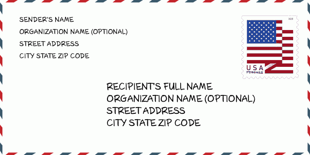
07719-3660 Przykład Koperty

-
To jest przykład koperty amerykańskiej. Wpisz informacje o nadawcy w lewym górnym rogu i informacje o odbiorcy w prawym dolnym rogu. Niezbędne informacje to imię i nazwisko nadawcy/odbiorcy, adres, miasto, województwo i kod pocztowy. Dane adresowe odbiorcy zostały podane w celach informacyjnych. Ogólnie rzecz biorąc, jeśli nie masz pewności co do pełnego 9-cyfrowego kodu pocztowego, możesz wpisać tylko 5-cyfrowy kod pocztowy, aby uniknąć utraty paczki.
07719-3660 Podstawowe znaczenie
-
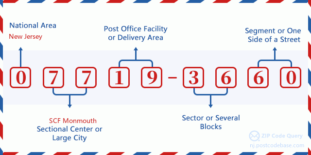
Co oznacza każda cyfra kodu pocztowego 07719-3660? Kod pocztowy + 4 składa się z dwóch części, pierwsze pięć cyfr może znajdować się w urzędzie pocztowym, a ostatnie cztery cyfry mogą identyfikować segment geograficzny w pięciocyfrowym obszarze dostawy. Cyfry 6-7 oznaczają sektor lub kilka bloków, a cyfry 8-9 oznaczają odcinek lub jedną stronę ulicy.

- ·ID Trasy Dostawy?
A 4-digit code assigned to a mail delivery or collection route within a 5-digit ZIP Code. The first character of this identification is alphabetical, and the last three are numeric: Bnnn = PO box Hnnn = Highway contract Rnnn = Rural route Cnnn = City delivery Gnnn = General delivery: C013 (Dostawa Miejska)
- ·Sektor Niski ZIP Dodatku?
The ZIP Add-On Low Sector and the ZIP Add-On Low Segment together form the ZIP Add-On Low Number. The ZIP Add-On Low Number is the last four positions of a ZIP+4 code; the low-end ZIP add-on in a range of codes; the add-on of the first ZIP+4 code in a consecutive series of ZIP+4 codes assigned to the delivery address. For example, most delivery addresses are assigned a single ZIP+4 code. However, large companies may be given a range of ZIP+4 codes that can be used to route mail to specific departments. A range of ZIP+4 codes can also be assigned to a corresponding range of post office boxes, and each box is mapped, one-to-one, with a ZIP+4 code in the range. A single post office box can also be assigned a range of ZIP+4 codes.: 36
- ·Segment Niski ZIP Dodatku?
The ZIP Add-On Low Sector and the ZIP Add-On Low Segment together form the ZIP Add-On Low Number. The ZIP Add-On Low Number is the last four positions of a ZIP+4 code; the low-end ZIP add-on in a range of codes; the add-on of the first ZIP+4 code in a consecutive series of ZIP+4 codes assigned to the delivery address. For example, most delivery addresses are assigned a single ZIP+4 code. However, large companies may be given a range of ZIP+4 codes that can be used to route mail to specific departments. A range of ZIP+4 codes can also be assigned to a corresponding range of post office boxes, and each box is mapped, one-to-one, with a ZIP+4 code in the range. A single post office box can also be assigned a range of ZIP+4 codes.: 60
- ·Sektor Wysoki ZIP Dodatku?
The ZIP Add-On High Sector and the ZIP Add-On High Segment together form the ZIP Add-On High Number, which is the high-end ZIP add-on in a range of codes; the add-on of the last ZIP+4 code in a consecutive series of ZIP+4 codes assigned to the delivery address. Most delivery addresses are assigned a single ZIP+4 code; however, large companies may be given a range of ZIP+4 codes that can be used to route mail to specific departments. A range of ZIP+4 codes can also be assigned to a corresponding range of post office boxes, and each box is mapped, one-to-one, with a ZIP+4 code in the range. A single post office box can also be assigned a range of ZIP+4 codes. (See also ZIP Add-On Code.): 36
- ·Segment Wysoki ZIP Dodatku?
The ZIP Add-On High Sector and the ZIP Add-On High Segment together form the ZIP Add-On High Number, which is the high-end ZIP add-on in a range of codes; the add-on of the last ZIP+4 code in a consecutive series of ZIP+4 codes assigned to the delivery address. Most delivery addresses are assigned a single ZIP+4 code; however, large companies may be given a range of ZIP+4 codes that can be used to route mail to specific departments. A range of ZIP+4 codes can also be assigned to a corresponding range of post office boxes, and each box is mapped, one-to-one, with a ZIP+4 code in the range. A single post office box can also be assigned a range of ZIP+4 codes. (See also ZIP Add-On Code.): 60
- ·PNA Dodatek: 3660
- ·Zakres?
The range of +4 codes. Summing the +4 Code and the +4 Range will give you the high end of the range of +4 Codes that pertain to this ZIP Code.: 0
- ·Kod Alternatywny Bazy?
Code that specifies whether a record is a base (preferred) or alternate record. Base records (represented as "B") can represent a range of addresses or an individual address, such as a firm record, while alternate records (represented as "A") are individual delivery points. Government deliveries will only be listed on alternate records with the appropriate government building indicator (federal, state, or city) set.: Baza
- ·Numer Finansowy?
A code assigned to Postal Service facilities (primarily post offices) to collect cost and statistical data and compile revenue and expense data. The state number comprises the first two positions of the finance number.: 330645
- ·Numer Dystryktu Kongresowego?
A standard value identifying a geographic area within the United States served by a member of the US House of Representatives or Senate. If Army/Air Force (APO) or fleet post office (FPO), this column will be blank. If there is only one member of Congress within a state, the code will be "AL" (at large).: 04
- ·Preferowany Klucz Miasta Stanu Ostatniej Linii?
An index to the City State file that provides the preferred last-line name for this address range.: 003670
Mapa

To mapa sieciowa adresu 2000 MILL POND CT, WALL TOWNSHIP. Mapę można przybliżyć. Mapa przeznaczona jest wyłącznie dla celów informacyjnych.
Adres: 2000 (From 2000 To 2099) MILL POND CT, WALL TOWNSHIP, NJ 07719-3660, USA
Komentarz


Dodaj komentarz